When I first began working on Elkinite, I thought one of the most powerful parts of the site was the ideas section. I imagined it as a place where we could share ideas and plans that are impossible within the walls of our minds, but entirely possible when shared with a community of knowledge, resources, and talents.
Here is one of those ideas.
In the past few months, I’ve driven from Elkins to Mill Creek more times that I can count. Along the way I’ve memorized the details of the eighteen mile drive. I’ve grown familiar to the curves, the lumber yards, open fields, and all the details between. So a few weeks ago when I noticed something different—the moving of the railroad tracks near the Tygart Valley Transfer Station— I took noticed and hatched an idea.
The Tygart Valley Trail.
A ten mile trail stretching from Dailey to Elkins—with potential to connect to the Allegheny Highlands Trail and the Greenbrier River Trail at Cass—that could prove to be a valuable asset to the community and create a potential for new economic opportunities.
The Plan
First; I must admit that beyond articulating this idea, I have no idea how to move forward. I can only hope that someone else has the knowledge and know how to make this plan work or to point out the impossibilities. I am also making an assumption that this rail route is unused. I could be wrong, but I hope I’m not because I feel that this trail provides opportunity to highlight communities in our region that often fly under the radar and that are often excluded from projects like this. So while the trail ends in Elkins, the heart of it is up the valley.
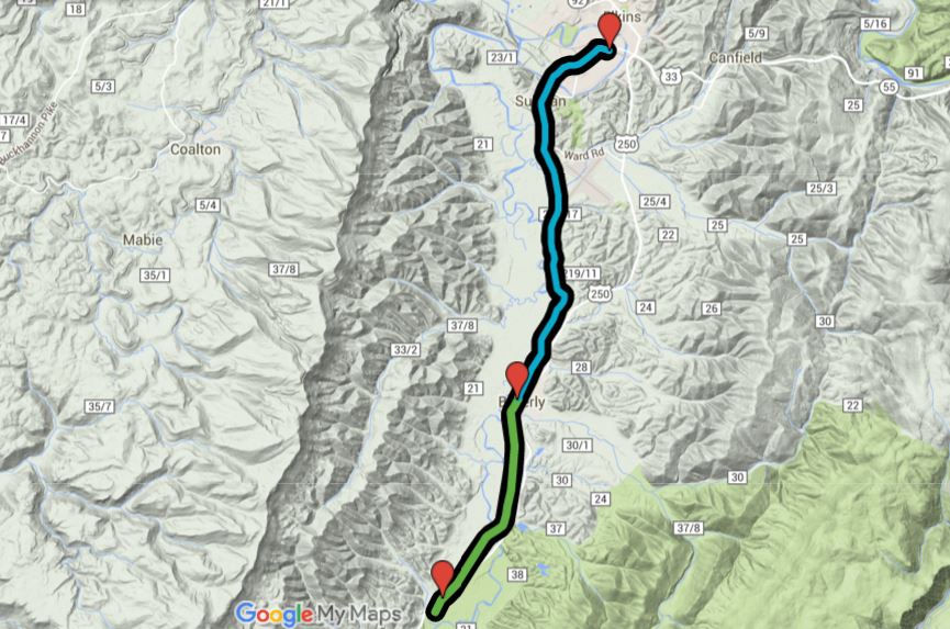
Section 1: Dailey to Beverly (approximately 3.69 miles)
Starting with a trailhead at the Dailey Post Office and Dailey Trade Center (with about .25 miles of trail before the trailhead as a note of the goal to expand further south), the path crosses Route 219 and passes through lumber yards and some farmland before crossing the Tygart Valley River (1.39 miles). After crossing the river the trail approaches and passes through the Armstrong World Industries Plant (1.69) and Colonial Millworks (2.29) before approaching residential areas outside Beverly. The trail arrives in Beverly (3.0) and ends about a half mile later at Railroad Street.
Within 500 feet of the end of the trail in Beverly are Campbell’s Market, Beverly Bistro, Randolph County Museum, Beverly Heritage Center, the Lemuel Chenoweth Museum, and a few other shops and historic sites.
While connecting the historic Dailey Trade Center with Beverly can been seen as the highlight of this section, I think the real potential—and value—of this section is its ability to serve a practice purpose for residents.
I often times see people walking and biking along the highway. This pathway creates a safe alternative for those already commuting on foot or bike. In so this also creates a chance to grow the workforce by connecting places of residence to places of work; allowing those without reliable transportation gain employment. The presence of the trail and a potential for an increased workforce will raise property values for landowners and create space for businesses to start or expand.
Section 2: Beverly to Elkins (6.32 miles)
This section picks up where the other section stops on Railroad Street. The trail exits Beverly and meanders through some woodlands and farmland as it clings to the banks of the Tygart Valley River. The trail then passes through the Elkins Golf Course (5.00) and the Pegasus Farm Campground (6.25) as it begins to approach Ward Road and Fox Forest WMA. Then the trail crosses the Tygart Valley River (8.25) and enters South Elkins. The trail crosses Livingston Avenue, 15th Street, and South Davis Avenue before terminating in the brick area near 12th Street. This places the trail within less than a mile of the Allegheny Highlands Trail providing access to over 25 miles of trail ending in Hendricks, WV.
A map of the proposed route of the Tygart Valley Trail.
Final Dreams
This is a huge endeavor. One that I think is entirely possible if those with answers and abilities come forward to make it work. I also think that if we come together to make this and similar projects work that we can all reap benefits for years to come. Benefits that can be seen in the success of similar trail systems, such as the Greenbrier River Trail, to our south.
Which reminds me: the Greenbrier River Trail in Cass is about 40 miles away from the start of this proposed trail in Dailey. Just imagine the regional impact could be had if it were possible to have a continuous path from Lewisburg to Thomas. That could be a real game changer for a lot of communities and people.
So I encourage you to dream with me. Come together and help this wild and crazy idea happen or send an email to elkinite@elkinite.stnhvn.net with your own vision. We’d love to provide a platform for crazy and impossible dreams to happen.


